






Richerenches
R11 Entre Vignes Lavandes et Truffières
logo
Route
Difficulty
Duration
Distance
Elevation gain
Altitude
R11
Boucle
Facile
3h
9km
+ 38 metres
- 38 metres
Min. 131 metres
Max. 158 metres
Max. 158 metres
Downloads
Contact details
Office de Tourisme Pays de Grignan - Enclave des Papes
Phone :
Show the phonenumber
E-Mail :
Show the email

A walk combining countryside and historic heritage. Interpretation panels.
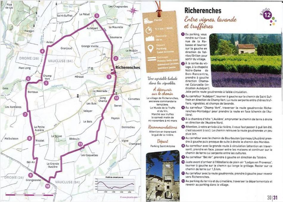
The hike in
Locatione in Richerenches :
In the north of Provence, the villages today comprising the Enclave des Papes share a rich and complex history and geography with the communes of Bas-Dauphiné.The coming of the Popes to Avignon in the early 14th century made these lands politically and economically important. These new overlords greedily bought up the land all around, seeking to expand the Comtat Venaissin to the north, into the lands of the Dauphiné. Their acquisitions remodelled the region’s geopolitics; the papal boundaries were the most direct expression of the expansion of the Popes’ influence.
The new owners took care to demarcate their newly acquired lands with precise boundary markers on the borders of their properties. Thus, a number of papal enclaves sprang up in the Dauphiné.
A series of boundary-marking campaigns were carried out following these acquisitions, the remnants of three of which can still be seen today: 1324, 1414 and 1457. Twenty-four boundary markers lie on the present-day limits of the canton of Valréas / Enclave des Papes.
They are stone slabs 30 cm thick, 40 cm wide and 150 cm tall, carved with one or more coats of arms representing the identities of the feudal lords whose lands they are demarcating. Some are marked with one or two lines on top to show the direction of the territorial limits. The arms of the Comtat Venaissin, belonging to the pope, were two crossed keys; those of the Dauphins showed a dolphin. Occasionally, a third coat of arms specifies the identity of a particular feudal lord of the Dauphiné. Thus, on a marker near Bollène, we see the cross of the Bishop of Viviers. These papal boundary markers in our present-day landscape are an irrefutable reminder of our history. To discover them is to walk ancestral paths, offering much food for thought and serving as a pretext to explore the region. The papal boundary markers are currently being systematically catalogued.
In brief
A découvrir sur le chemin :
- Le village de Richerenches
- Le musée de la truffe
- le marché aux truffes le samedi matin de mi-novembre à mi-mars
Contact
R11 Entre Vignes Lavandes et TruffièresParking Saint Antoine
84600 Richerenches
Phone :
Show the phonenumber
E-Mail :
Show the email
Accéder à l'itinéraire
Public transport
Parking(s) conseillé(s)
Parking Saint-Antoine
Accès routier
Depuis la route de Valéras, rejoindre Richerenches via la voie partant au nord du rond-point (Avenue de la Rabasse)
A noter
Attention en traversant le gué de la rivière.
 Vous souhaitez nous signaler un problème sur votre randonnée ? (balisage, entretien, danger….), prévenez nous sur : Suricate
Accès aux massifs
Respecter les réglementations de préservation des zones naturelles protégées - se renseigner sur les conditions pour accéder aux massifs en période de risque incendie, du 15 juin au 15 septembre.
Avant toute sortie, Visit the website
Respecter les réglementations de préservation des zones naturelles protégées - se renseigner sur les conditions pour accéder aux massifs en période de risque incendie, du 15 juin au 15 septembre.
Avant toute sortie, Visit the website